
On Friday evening, a major winter storm swept through the Northeast, marking the heaviest snowfall in Boston in nearly three years. What was initially anticipated to be a routine winter weather event quickly turned into a significant disruption, especially for travelers during one of the busiest holiday weekends of the year. The storm, which dropped several inches of snow across a large portion of the region, caused severe travel delays, hazardous driving conditions, and significant disruptions at major airports, including Boston Logan and New York City’s airports.
This winter storm, fueled by a combination of an Alberta Clipper system and a coastal low-pressure system, left cities like Boston blanketed in snow and millions of people braving tricky travel conditions. The event caused over 13,000 flight delays and hundreds of cancellations on Friday alone. The effects of the storm were felt across multiple states along the Interstate 95 (I-95) corridor, from Philadelphia to New York City to Boston.
The Storm’s Path: Snowfall Across the Northeast
Snowfall Accumulations in Boston and Surrounding Areas
By Saturday morning, Boston and several areas of eastern Massachusetts, Rhode Island, and eastern Connecticut had received between 3 to 6 inches of snow. The storm hit Boston particularly hard, with the city experiencing its most substantial snow accumulation since January 2022.
- Boston: Fenway Park recorded 6 inches of snow, and Logan Airport measured 5.2 inches.
- Providence, Rhode Island: Saw 2-3 inches of snow.
- Hartford, Connecticut: Similar snowfall accumulation to Providence, with around 2-3 inches.
Other cities along the I-95 corridor, including New York City, saw lighter accumulations of snow, typically less than 2 inches. Despite this, the cold temperatures and icy roads presented significant challenges for commuters and travelers.
A Fast-Moving System: The Alberta Clipper
The storm originated from an Alberta Clipper—a fast-moving weather system typically characterized by its speed and intensity. The Clipper moved out of Canada and quickly dropped snow across the Northeast. This system, while efficient in delivering snow, also caused a sudden shift in weather, with temperatures rapidly plummeting.
In addition to the Clipper, a coastal low-pressure system formed off the East Coast, amplifying the storm’s strength. This combination of systems is what led to the heavy snowfalls and tricky conditions along the I-95 corridor.
Disruptions at Airports: Delays and Cancellations
Major Airports Affected: Boston Logan and New York City
The winter storm was not just a problem for those traveling by car but also created massive disruptions for air travel. Airports in Boston, New York City, and Philadelphia were some of the hardest-hit. The storm’s timing, during the holiday travel season, meant that over 13,000 flights were delayed and hundreds were canceled.
- Boston Logan Airport: Over 5 inches of snow accumulated, which, combined with poor visibility and deicing efforts, significantly slowed air traffic.
- New York City Airports (JFK, LaGuardia, and Newark): Many flights were either delayed or canceled due to the storm’s impact on ground operations and flight schedules.
The snowstorm caused issues for airlines and passengers alike. Travelers were stranded or faced significant delays, with some reporting long wait times to rebook flights or receive updates on cancellations. These disruptions highlighted the challenge of maintaining air travel schedules in adverse weather conditions, particularly during peak travel periods.
Flight Delays and Cancellations Across the Northeast
The effects of the storm were felt far beyond Boston and New York. Flights across the Northeast were severely impacted. Major delays were reported not just at airports in Boston and New York, but also in Philadelphia and Providence. The snowstorm caused widespread operational slowdowns at many airports, leaving thousands of passengers stranded or rerouted.
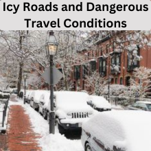
Icy Roads and Dangerous Travel Conditions
Impact on Roadways: Accidents and Road Closures
The snowstorm also led to hazardous road conditions across the region. As snow accumulated quickly, driving became dangerous, especially during the evening commute on Friday. The combination of snow, ice, and poor visibility led to multiple accidents and road closures.
- Interstate 90/Mass Pike: This major route in Massachusetts was closed for several hours after multiple semi-trucks collided on the eastbound lanes. Fortunately, no one was seriously injured, though the crash disrupted traffic for hours.
- Interstate 95: The I-95 corridor, which runs from Philadelphia to Boston, saw reduced visibility and slippery conditions, making travel difficult for motorists.
In addition to accidents, plowing efforts were hampered by the intensity of the snowfall. Boston Public Works deployed nearly 400 pieces of equipment to treat and clear the roads, but the snow had already created a number of hazardous situations by the time they began working.
Also read: Which Christmas Cookie Reigns in Your State? Find Out
The Role of Coastal Low Pressure and East Coast Energy Transfer
Understanding the Weather Systems at Play
As the storm made its way down the East Coast, it tapped into a weather phenomenon known as “East Coast energy transfer.” This occurs when the energy from a fast-moving system like the Alberta Clipper combines with the coastal low-pressure system, intensifying the snowstorm.
- Alberta Clipper: A quick-moving system that brings cold air and light to moderate snow.
- Coastal Low Pressure: A storm that strengthens along the coast, drawing moisture from the Atlantic and amplifying the snowfall.
This combination of systems created the heavy snowfalls along the I-95 corridor and contributed to the icy conditions on the roads and at airports.
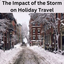
The Impact of the Storm on Holiday Travel
Travel Chaos During the Busiest Time of Year
For many travelers, the timing of the storm could not have been worse. With the winter holidays in full swing, millions of Americans were hitting the roads and taking flights to visit family or go on vacation. The snowstorm disrupted these plans for thousands of people, particularly in the Northeast.
Airlines and ground transportation systems were overwhelmed by the volume of people attempting to travel, and the storm’s arrival only compounded the challenges. Thousands of travelers were left stranded in airports or stuck in traffic for hours.
Forecasting the Future: What’s Next for the Northeast?
Upcoming Cold Snap and Snowfall Predictions
After the snowstorm passed, temperatures across the Northeast were expected to drop dramatically. By early next week, parts of the region were predicted to experience sub-zero temperatures, with wind chills making it feel even colder.
- Sub-Freezing Temperatures: The snowstorm would be followed by a significant cold snap, with temperatures in the teens and single digits predicted for much of the Northeast.
- Christmas Weather Outlook: While the immediate aftermath of the storm was cold and snowy, temperatures were expected to rebound slightly by Christmas, offering a respite for those planning to travel during the holiday week.
Also read: SpaceX’s Bandwagon-2 Launch: A Game-Changer for Space
Conclusion
The winter storm that hit the Northeast was a reminder of how unpredictable and disruptive winter weather can be. Boston, a city accustomed to heavy snowfalls, recorded its largest accumulation in nearly three years. For travelers, this storm created chaos, with delays and cancellations impacting thousands during one of the busiest travel periods of the year.
Despite the challenges, the storm also served as a testament to the resilience of both the cities and their residents. Snow removal crews worked tirelessly, and airports scrambled to clear runways and get flights back on track. As temperatures drop, the region is bracing for another cold stretch, making this winter storm a significant chapter in the region’s weather history.
FAQs
How much snow did Boston receive during the storm?
Boston saw approximately 5-6 inches of snow, with Fenway Park recording 6 inches and Logan Airport reporting 5.2 inches.
What caused the heavy snowfall in the Northeast?
The snowstorm was caused by a combination of an Alberta Clipper weather system and a coastal low-pressure system, which intensified as it moved along the East Coast.
How did the storm impact travel in the Northeast?
The storm caused widespread flight delays and cancellations, with over 13,000 flights delayed on Friday alone. Road conditions were also hazardous, leading to accidents and road closures.
What is an Alberta Clipper?
An Alberta Clipper is a fast-moving weather system that typically brings cold air and light to moderate snow. It’s known for its rapid progression and quick snowfall.
How will the weather in Boston change in the coming days?
Following the storm, temperatures in Boston are expected to drop into the teens and single digits, with a cold snap lasting through early next week. However, temperatures are expected to rebound slightly for Christmas.