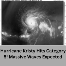
Hurricane Kristy, a powerful Category 5 storm, has captured global attention as it churns over the open waters of the Pacific Ocean. Although Kristy is not expected to make landfall, the storm is a stark reminder of the growing intensity of tropical systems in the Pacific. High surf and dangerous rip currents are anticipated along the western coast of Baja California, where residents are advised to stay alert. With its exceptional strength, Hurricane Kristy exemplifies the need to track hurricanes closely, even those that remain far from shore.
Overview of Hurricane Kristy
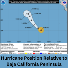
Hurricane Kristy began as a tropical storm off the southern Pacific coast of Mexico earlier this week. Gaining strength rapidly, it evolved into a Category 5 hurricane, the highest classification on the Saffir-Simpson scale. Currently located about 970 miles southwest of Baja California’s southern tip, Kristy is moving westward at a speed of 16 mph, packing maximum sustained winds of 160 mph.
What It Means to Be a Category 5 Hurricane
Category 5 hurricanes are rare and defined by their ferocious wind speeds and potential for catastrophic damage. On the Saffir-Simpson scale, a Category 5 storm must have sustained winds of at least 157 mph. This classification indicates the potential for complete destruction in areas of direct impact, making these storms some of the most closely monitored by meteorologists. Although Kristy is not expected to reach populated areas, its strength is a reminder of the powerful forces that tropical cyclones can unleash.
Tracking Hurricane Kristy’s Path
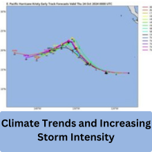
Meteorologists are closely monitoring Hurricane Kristy’s movement across the Pacific Ocean. According to the National Hurricane Center (NHC), Kristy’s projected path shows it continuing westward, keeping it away from populated areas. This westward track is typical for hurricanes that form in the Pacific, as they are often pushed by high-pressure systems that prevent them from turning toward land.
Hurricane Position Relative to Baja California Peninsula
Despite Hurricane Kristy’s significant distance from land, its effects are still anticipated along parts of the Baja California peninsula. The NHC has indicated that Kristy’s outer bands may create strong surf conditions and rip currents, particularly on the peninsula’s west coast. While the storm remains hundreds of miles away, the coastal areas are urged to stay aware of the potential risks from waves and currents.
No Current Landfall Expected
As of the latest forecasts, Hurricane Kristy is not projected to make landfall. This trajectory is partly due to the Pacific’s prevalent wind patterns, which push the storm westward into the open ocean. However, as the storm is still powerful, forecasters continue to track its progress to ensure coastal areas stay informed of any changes.
Dangerous Waves and Rip Currents Expected
The biggest concern with Hurricane Kristy for coastal areas is the increased wave activity and dangerous rip currents along the west coast of Baja California. Rip currents are powerful channels of water flowing away from shore, and they can quickly sweep even strong swimmers out to sea. With waves expected to rise significantly, beachgoers and surfers should exercise caution, as even the best swimming skills may not be enough to combat these strong currents.
Impact on West Coast Surf Conditions
For residents and visitors to the Baja California coastline, Hurricane Kristy’s effects will likely be most visible in the form of large waves and turbulent surf. These conditions are anticipated to last through the weekend, making it essential for beach communities to remain vigilant. Authorities typically advise against swimming in these conditions and urge people to heed any warnings about coastal water safety.
How Coastal Communities Should Prepare
Though Hurricane Kristy is expected to remain offshore, coastal residents and visitors should still prepare for possible high surf and dangerous currents. Local officials may close beaches or issue warnings to ensure public safety. Being prepared for these types of natural events means staying informed, following local advisories, and avoiding risky activities in affected waters.
Why Hurricanes Weaken Over Open Waters
Hurricanes rely on warm, moist air to sustain their strength, which they draw from the ocean’s surface. However, as storms move westward into cooler waters or encounter wind shear, they can start to lose power. Environmental factors, like dry air, can also disrupt a hurricane’s structure, causing it to weaken. Forecasters predict that Hurricane Kristy will follow this typical pattern, gradually losing strength as it drifts over cooler waters.
Also read: Costco Recalls Chicken! Is Your Meal Safe from Listeria?
Weather Conditions Contributing to Weakening
Various atmospheric conditions contribute to the weakening of hurricanes. Wind shear—variations in wind speed and direction—can disrupt a storm’s organization, while cooler water temperatures limit the heat energy available. As Hurricane Kristy progresses, it’s expected to encounter these unfavorable conditions, leading to a gradual decrease in wind speed and intensity.
Climate Trends and Increasing Storm Intensity
Climate scientists have noted an upward trend in the intensity of storms in recent years. Warmer ocean temperatures, fueled by climate change, provide more energy to hurricanes, resulting in stronger storms. This trend is noticeable in both the Pacific and Atlantic basins, with more frequent instances of hurricanes reaching Category 4 and 5 status. Understanding this pattern helps scientists anticipate future hurricane behavior and better prepare coastal areas.
Pacific Hurricanes vs. Atlantic Hurricanes
Pacific hurricanes, while generally less impactful on land than their Atlantic counterparts, often grow larger due to the vast open water. They also tend to track westward, posing a lesser threat to populated areas. However, Pacific hurricanes can still cause significant coastal hazards, especially in areas where tourism and recreation rely on safe surf conditions. This year’s active Pacific hurricane season, highlighted by Hurricane Kristy’s rapid intensification, raises awareness about the unique patterns of tropical cyclones in the region.
The Importance of Advanced Hurricane Tracking
Hurricane forecasting has evolved significantly, with technology like satellite imagery and advanced computer models providing accurate storm path projections. For storms like Hurricane Kristy, this technology allows forecasters to predict trajectories, wind speeds, and even the chances of landfall. Improved tracking helps protect coastal communities by providing the information they need to make timely preparations.
Also read: Shocking Twist: Menendez Brothers’ Uncle Fights for Justice
Conclusion
Hurricane Kristy’s rise to a Category 5 hurricane in the Pacific Ocean underscores the power of nature and the importance of vigilance. While the storm is expected to weaken and remain offshore, its presence highlights the need for ongoing awareness of hurricane activity, especially as storm intensity trends upward. Staying informed and following safety protocols can help ensure communities remain resilient in the face of such powerful natural forces.
FAQs
-
What makes a storm a Category 5 hurricane?
- A Category 5 hurricane has sustained winds of at least 157 mph, posing extreme risks of destruction if it reaches land.
-
Is Hurricane Kristy expected to reach land?
- No, forecasters predict that Hurricane Kristy will stay in open waters, away from populated areas.
-
Why do hurricanes weaken in open waters?
- Hurricanes lose strength when they encounter

